Scientists ridiculed Alfred Wegener’s theory of continental drift for many years; however, none could replace it with a better theory.
By the mid-1960s, maps of the seafloor revealed a new picture of our planet. The seafloor was found to be very young compared to the continents, with the youngest rock located in the middle of the ocean. It was found that the age of the rock was progressively older the nearer it was to the continents. There was a long mountain range in the middle of the ocean called a mid-ocean ridge. The youngest rocks were found in a valley running down the length of a mountain range called the rift valley. Magnetic patterns in the ocean rock were symmetrical around the mid-ocean ridge, as was the age of the rock. It appeared that the ocean floor was being torn open at the rift valley. Molten rock was oozing up in the gap and hardening into new seafloor. Over time, repeated fissures and accompanying lava flows caused the ocean floor to spread. This became known as seafloor spreading.
Read the following excerpt from the US Geological Survey about the theory of seafloor spreading. As you read, pay close attention to the evidence scientists found that showed how and why seafloors spread.
Harry Hess, a professor of geology at the Princeton University, and others suggested an idea that they called seafloor spreading. They proposed that the ocean floor was splitting open. Magma from within the earth would rise and fill the fissures created by the splitting motion. This magma would harden into young ocean rock. The process would repeat, creating new ocean floor each time the floor split. In time, the ocean floor would grow wider and wider. New ocean floor was being created at spreading regions in the rift valley, which ran down the middle of the mid-ocean ridges. The idea of the spreading of the seafloor caused a revolution in the earth sciences.
Evidence for Hess’s theory of seafloor spreading came from many sources, including the high heat flow out of the mid-ocean ridge. The youngest oceanic rock was found in the ridge, and progressively older rock was found farther out from the ridge. This age pattern was also nicely explained by seafloor spreading. This idea also explained the fact that the thickness of sediment on the ocean floor was not uniform. The ridge had very little sediment. Sediment thickness increased on either side of the ridge. The most convincing piece of evidence was that the magnetic pattern in the ocean rock was symmetrical on either side of the ridge. This magnetic symmetry provided irrefutable data that convinced the scientific community that the ocean floor was indeed spreading as Hess and his colleagues had theorized. (You can see an example of this theory at this animated GIF.)
With the realization that the seafloor was spreading, it was not long until the scientific community realized that this spreading of the seafloor would cause the continents to move. Alfred Wegener was right—the continents had “drifted,” but not in the way he had imagined. The two ideas of continental drift and seafloor spreading merged into one theory, called plate tectonics. The theory of plate tectonics states that the earth’s crust is broken into large and small pieces, or lithospheric plates, that are moving around. These plates rest on denser, fluid-like layers within the earth. You’ll learn more about these fluid layers and how they are created in the next unit.
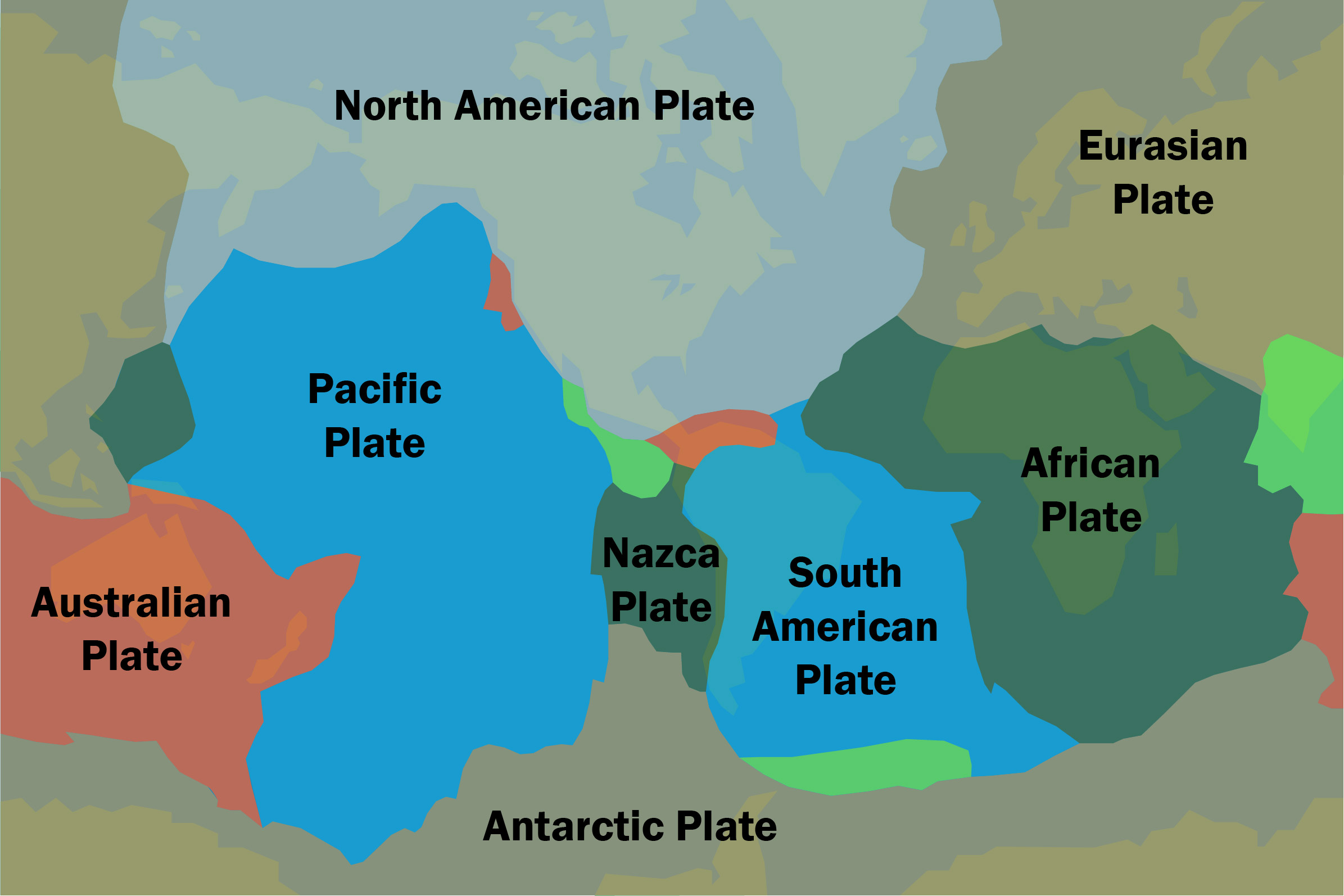
A tectonic plate is a large section of the earth’s crust. The single largest plate is the Pacific Plate. This plate makes up a large portion of the floor of the Pacific Ocean. It is almost entirely made of oceanic crust. The South American Plate makes up the continent of South America and a large section of the floor of the Atlantic Ocean. The plate with the largest landmass is the Eurasian Plate. Nearly all of Europe and Asia are on this plate. It is almost entirely made of continental crust. In all, scientists have mapped about twenty plates.
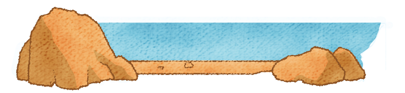
The word tectonics comes from the Greek word tektonikos, (root tekton, meaning builder) which means “pertaining to building.” As the plates move around, they collide, pull apart, and slide past each other. Collisions between plates cause mountain ranges to form. They also create deep valleys or trenches on the seafloor. When plates pull apart, they produce mid-ocean ridges. The ridges in each ocean are part of a mountain range that is nearly 40,000 miles long and that winds through the world’s oceans. When plates slide past each other, they produce transform faults like the famous San Andreas Fault of Southern California. Over time, these three plate interactions have created, or “built up,” the major features of the earth’s surface.
One hallmark of a good scientific theory is that it can be used to make predictions that can be tested. If the predictions hold up and the evidence gathered from such tests and experiments validate the theory, the idea is strongly supported. The plate tectonic theory has explained the thickness of sediment on the seafloor, the locations of volcanoes and earthquakes, the magnetic patterns in the rock of ocean floor, and the ages of oceanic and continental crust.
Scientists had long thought that the ocean basins were primordial features of the earth. The basins were believed to be at least four billion years old. If this were true, for all those billions of years, sediment would have been washed off the continents and deposited in layers of mud and gravel on the bottom of the sea. Consequently, sediment layers on the seafloor would be extremely thick.
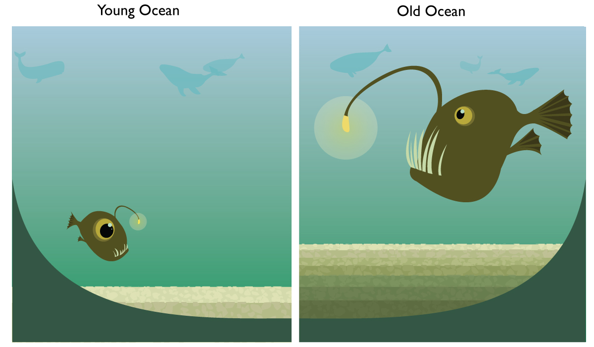
Plate tectonic theory, however, predicts that the ocean floor is very young. Accordingly, the ocean basins would have very little sediment. The test came when the thickness of the sediment on the floor of the oceans was measured. Scientists found that in the areas of mid-oceanic ridges, there was hardly any sediment at all. The sediment grew thicker as measurements were made near the continents, but it was nowhere near as thick as it would be if the oceans were four billion years old. Plate tectonic theory has accurately predicted the thinness of the ocean floor sediment.
Scientists had known for many years that earthquakes occurred when stress built up in the crust. The sudden release of the stress produces the vibrations that are felt as an earthquake.
According to the plate tectonic theory, when two adjacent plates move, there is a great deal of stress within the rock. If the crust were, in fact, pulling apart, this motion and the stress in the rock that it produced would trigger many earthquakes. Earthquakes would therefore be common along the edges of the plates.1
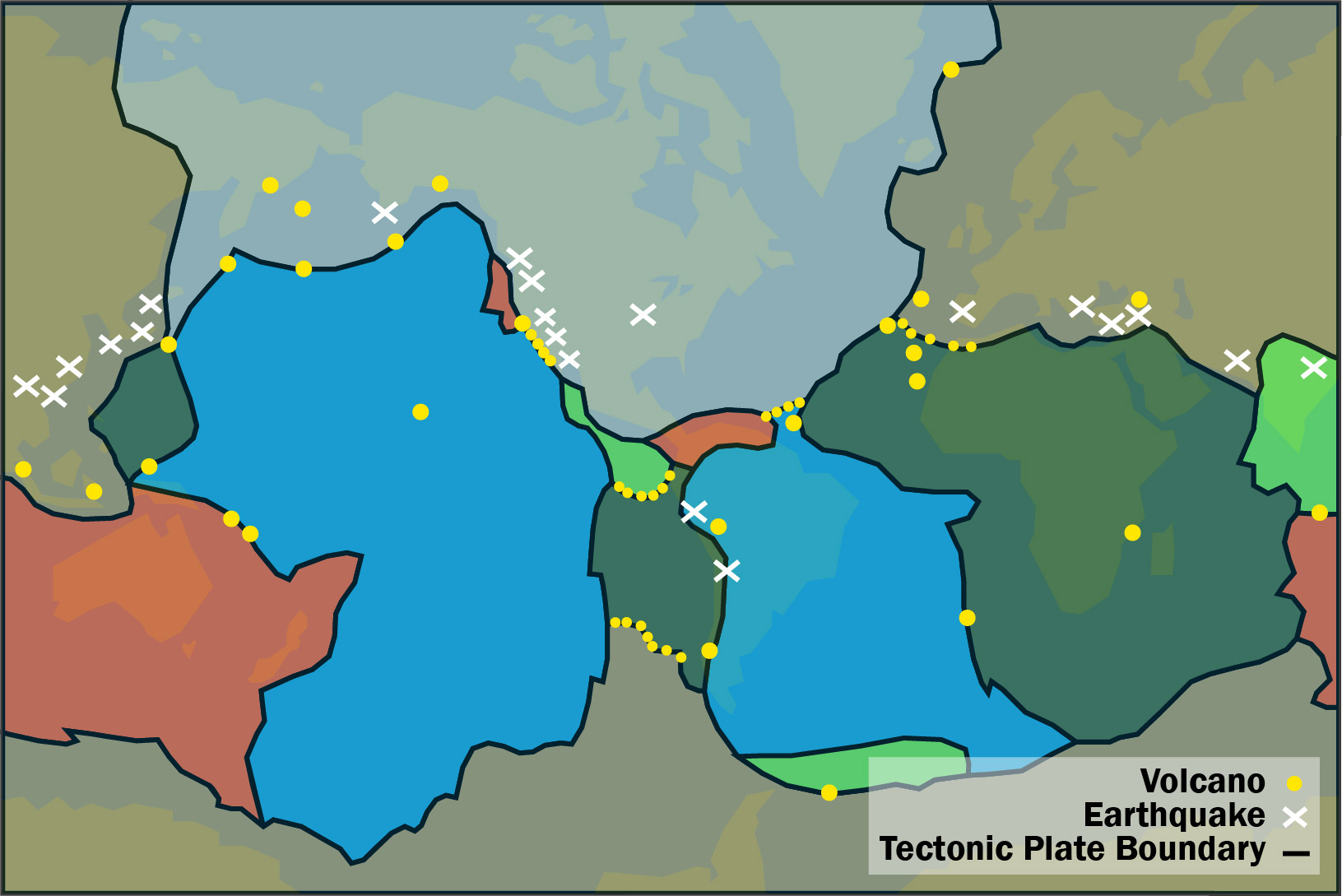
During the last half of the twentieth century, a worldwide system of seismographs enabled scientists to learn that earthquakes occur along the oceanic trenches and mid-ocean ridges. The data allowed scientists to precisely map the zones of earthquake activity worldwide. Scientists discovered that earthquakes form patterns that outline large sections of the earth. The sections look like giant pieces of a jigsaw puzzle. The earthquake pattern of the earth is just like the theory predicted it would be.
Volcanic studies at the same time recognized that the location of most of the earth’s volcanoes coincided with the locations of the earthquake zones. This fact is also neatly explained by the motion of the plates.
As a plate moves, it can pull apart from or collide with its neighbor. When plates pull apart, the pressure on the underlying rock is released. This causes the rock to melt into magma. The magma rises to the surface and erupts. If the two plates collide, one plate will be forced beneath the other or in other words, the plate subducts. This subducting plate is eventually melts as it plunges down into the interior of the earth. Large masses of molten rock are formed by the subducting plate. This molten rock rises and erupts onto the surface, producing volcanoes.
The edges of the plates can be located and mapped by using the data on earthquakes and volcanoes. See the following map that shows the locations of earthquake zones. The fact that plate tectonic theory predicts this pattern is strong supporting evidence of the theory. No other geologic theory predicted such patterns.
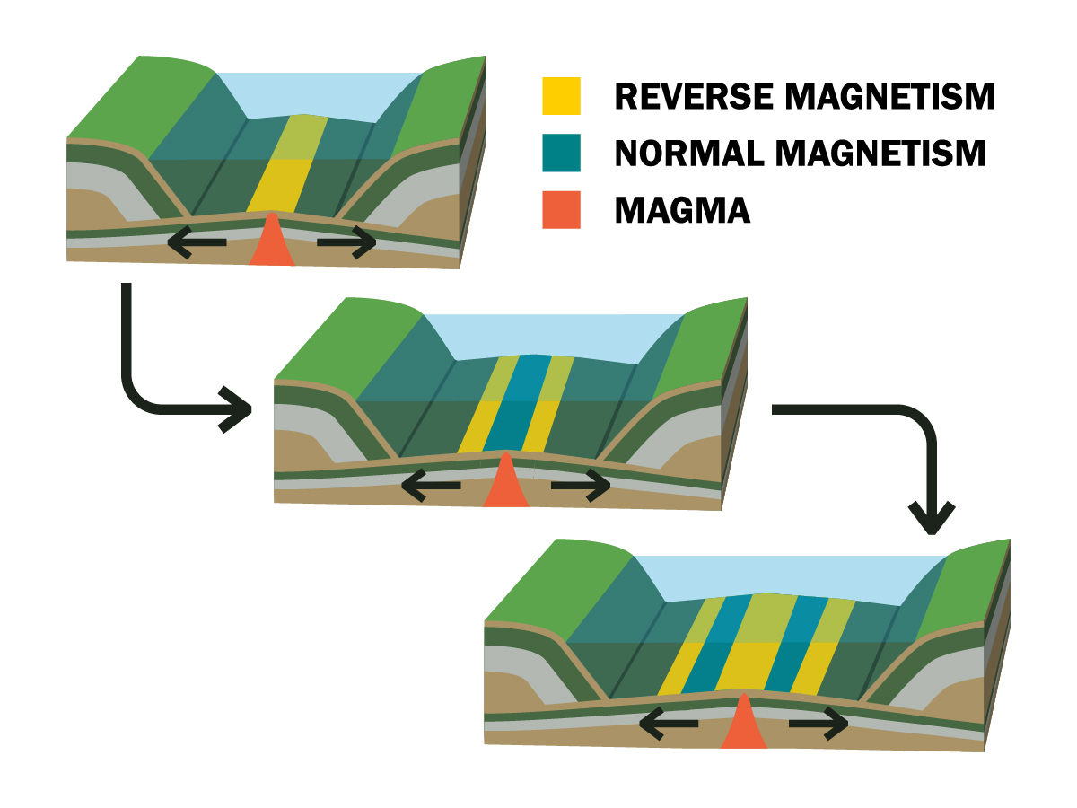
Another test for plate tectonics came from the magnetic patterns of the rock on the seafloor. During World War II, scientists and the military developed magnetic-detection instruments (magnetometers) to detect submarines. These same magnetometers also detected the magnetic patterns in the basalt rock of the ocean floor.
Basalt rock contains iron-bearing minerals. While molten, the iron minerals in the basalt are free to move. The minerals line up, pointing in the direction of the earth’s magnetic poles. Scientists recognized that sometimes the basalt was magnetized pointing north and sometimes it was reversed, pointing south. This followed the known pattern of Earth’s magnetic field: Earth’s magnetic field reverses itself, causing the reversal in the magnetization of the minerals in the basalt. The result is zebra-like stripes of magnetized basalt on the seafloor.
What further surprised the scientists was the symmetrical pattern of magnetism in the rock of the ocean floor. During the 1950s and 1960s, more and more of the ocean floor magnetism was mapped. The ocean floor showed magnetic strips that were symmetrical on either side of the mid-ocean ridge. The pattern of north and south magnetism on one side of the ridge matched with the other side, just like your right hand matches symmetrically with your left hand.
The old theories of ocean floor formation could not explain this magnetic pattern, but this pattern was easily explained by plate tectonics. As new crust forms in the ridge, it becomes magnetized. The lava cools and hardens, locking in the magnetic direction. When the seafloor spreads again, some of this rock is pulled to one side of the ridge, and some is pulled to the other side. After a time, more rock is formed and the spreading continues, producing a striped magnetic pattern on one side that matches the pattern on the other.
Earlier in this lesson, you learned about Harry Hess, who suggested that seafloors were spreading. Hess and his associates reasoned that if new seafloor is created at the mid-ocean ridges, then there must be places where it is also destroyed. They were right. The destruction of the seafloor occurs in the trenches. In the trenches, where two plates meet, seafloor rock is subducted back into the interior of the planet. The subducting oceanic crust eventually melts, becoming part of Earth’s interior. Thus, the seafloor is continually recycled, being created at the mid-ocean ridges and destroyed at the subduction zones along the ocean trenches. This recycling process nicely explains why the ocean floor is younger than the continents. The continental rock is lower in density and does not subduct.
Let’s summarize the evidence we’ve discussed so far that supports the tectonic plate theory:
Plate tectonic theory has predicted and explained how many features of the earth were formed. It is now considered a unifying theory of the earth. The simplicity of its ideas and its ability to explain so many geologic features of our planet stand as a hallmark in geologic discovery. Alfred Wegener died on an Arctic expedition while attempting to rescue several of the men in his exploration party. He would surely be proud of his “crazy idea,” which revolutionized our understanding and study of the earth.
1. This USGS site shows the size and location of earthquakes that happened around the world in the last seven days.